Tuesday, July 21, 2015

Cool 1945 map shows plenty of passenger rail into uptown Charlotte

In the category of "Found while looking up other stuff" I came across this amazing map of 1945 Charlotte, and all the passenger and freight rail lines that fed uptown. It's from a 1945 Chamber of Commerce brochure, and you can find it, too, on the website of the Charlotte-Mecklenburg Historic Landmarks Commission.

It's a little difficult to tell from the cute drawing how many of those rail lines carried passengers as well as freight, but the Piedmont and Northern to Gastonia was an electrified passenger rail - today we'd call it commuter rail.

The line is still used. It runs west and northwest from uptown Charlotte near the NFL stadium, through the Wesley Heights neighborhood, then crosses the Catawba River and goes through Mount Holly, Belmont and into Gastonia. The N.C. Department of Transportation owns much of the right-of-way, except for an important segment beyond Wesley Heights and the river, which is owned by CSX. (See final paragraph of this report.)

The old Southern Railway passenger terminal was on West Trade near what's now the Greyhound Bus station, but it was demolished years ago. The 1895 Seaboard Air Line depot, between North Tryon and North College streets - depicted on the 1945 map as S.A.L. RR now the Urban Ministry Center.

Rail junkies may enjoy this 2008 map of the N.C. rail lines, which lists ownership of the segments.
Wednesday, July 15, 2015

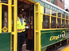
A chat with the godfather of Charlotte's streetcar

Driver Danny McQueen on Tuesday, awaiting a carload of dignitaries to launch Charlotte's streetcar. The historic replica streetcars now in use would be replaced during the expansion phase with modern streetcars. Photo: Mary Newsom
Before Tuesday morning's ribbon-cutting that launched Charlotte’s new streetcar, it seemed appropriate to check in with Ron Tober. It was Tober who originally proposed adding the streetcar to the larger transit plan for Charlotte. One might even dub him the godfather of the streetcar idea.

Tober was the Charlotte Area Transit System CEO from 1999 to 2007 – the longest-serving CATS chief to date.  The original transit plan, crafted before the 1998 voter referendum that OK’d a transit sales tax, did not include a streetcar. It roughly sketched five corridors: South (now the Lynx Blue Line), North (the still unfunded commuter rail to Mooresville), Northeast (being built as the Blue Line Extension), Southeast (envisioned running roughly down Independence Boulevard), and West possibly to the airport and possibly not.

Other than the South corridor, where the city already owned rail right of way, and the proposed extension to the northeast, it was left unclear in those early days which corridors would get bus rapid transit and which would get light rail. That did not sit well with east and west Charlotte neighborhood championswho clamored for rail service, not bus rapid transit.

In 2004, Tober proposed a streetcar to connect east and west Charlotte. It would run in rails along Beatties Ford Road, through uptown, and out Central Avenue to Eastland Mall, which at that time was open, he reminded me Tuesday morning. The streetcar idea was adopted into the 2006 transit plan update.

Some background: The newly opened 1.5-mile streetcar segment is not funded with the county’s half-cent sales tax for transit. That money goes to the Blue Line, the Blue Line Extension and to run the bus system. Not enough revenue has come in to pay to build more of the 2030 transit plan. (See New CATS chief faces funding questions.) The first streetcar leg was built with a $25 million federal grant and $17 million in funds from the city of

Wednesday, July 8, 2015

Highways - loosening our collective belts

The first vehicles drive down the final leg of I-485, June 5. Photo: Nancy Pierce
Even as the national discussion turns toward whether we are overbuilding highways, based on inflated state traffic numbers, in North Carolina those questions are rarely heard. Last month the state's largest city, Charlotte, population 800,000, where I live and work, saw the June 5 opening of the final leg of its loop highway.  It's called Interstate 485 but it doesn't touch another state, or even another county.

When the road was first discussed in the 1960s, the idea was to open more land for development, because in these parts, the growth-is-good mindset has not had much nuance to it. While the local news media saw headlines such as Last I-485 segment will be boon to locals, we at the UNC Charlotte Urban Institute, where I work and direct the PlanCharlotte.org website, decided to look deeper.

We've published some interactive maps that show just how much of the county's development has been shaped by the outerbelt highway here. A couple of images are reproduced below but find the interactive and zoomable versions at this link.


 In coming weeks we'll map population growth and traffic counts at the interchanges.

Obviously this is a fast-growing metro area, and growth was going to arrive regardless of where we put our freeways. The questions were: Where was the growth going to go? Can the highway capacity keep up with the demand created by the new development?

 The answer to the first question is now obvious. The growth flooded to the highway, leapfrogging closer in areas that even today lack for investment.  Would even more growth have leapfrogged into adjacent counties without I-485, or would the lack of the highway access have kept the development closer to the core? Who could tell?

The answer to the latter question remains unclear, although I certainly have my doubts. Even before the final link of the loop opened June 5, last December the first leg of the highway, which opened in the 1990s, was expanded from two to three lanes each direction, at a cost of $83 million.

It's still clogged.