Monday, December 7, 2015

Can Charlotte become more walkable and bikeable? The conversation continues


AARP volunteers get ready to begin a walkability audit uptown with guest speaker Gil Penalosa of 8-80 Cities in October.  Photo: Juan Ossa
It isn’t every day in Charlotte that within five hours you hear the World Health Organization invoked in conversation about planning and livability. But as a Charlotte discussion continues about whether the city needs to purposefully shift its primary emphasis away from motorists and toward to bicycles, pedestrians and transit, the “livability” term just keeps coming up.

Monday morning, I learned that the Town of Matthews in southern Mecklenburg County is the first, and to date only, municipality in North Carolina to sign on as an AARP Age Friendly Community.

That AARP initiative, as it turns out, is an affiliate of the WHO’s Age-Friendly Cities and Communities Program, a global effort dating to 2006 to help cities prepare for both increasing urbanization and for an aging population, as the huge Baby Boom generation hits retirement age.
Michael Olender, the Charlotte-based associate state director for AARP, says he’s in conversations with the Charlotte mayor’s office about whether Charlotte should also seek to join.

What does “age-friendly community” have to do with walkability and livability? Simply this: As planners and policymakers focus on the wishes and needs of the huge Millennial generation, Olender says, not much attention is being paid to the needs of what the older generation wants. But, he says, “What Boomers want mirrors very closely what Millennials want. They want to walk. They want good public transit.”

Fast-forward a few hours. I’m at the Charlotte-Mecklenburg Planning Commission’s monthly work session. Planning commissioner Deb Ryan, an associate professor of urban design at UNC Charlotte, is giving a short presentation on the role of livability and public health in city planning. She pointedly did not call it “sustainability.”

“ ‘Sustainability’ means everything and nothing,” Ryan said. Instead, she talked about becoming a “livable city.”

Friday, November 13, 2015

One N.C. city aims to protect older buildings with a height limit. (Hint: Not Charlotte)

Tall new buildings surround Romare Bearden Park in uptown Charlotte. Photo: Nancy Pierce
As discussion in Charlotte continues on how to protect the unique character of some older neighborhoods from intense development pressure, [Can Plaza Midwood save the places that matter?] one N.C. city is using a tool that's been available all along. That city is Raleigh. [With height caps, Raleigh hopes to protect historic buildings]

It's not a tool beloved by people who make money from building tall buildings. By limiting the heights of buildings, the city is, at heart, limiting the profitability of any development on that dirt. Note that overall, Raleigh wants to encourage tall buildings downtown, and density.  But with a cluster of 19 old, iconic buildings along its main downtown street, Raleigh wants to add a level of protection.

Most of the buildings that will get the height limits are on the National Register of Historic Places and Raleigh historic landmarks.  Under state and federal law, neither of those designations can prevent a building from demolition.

Charlotte also has height restrictions in some of its zoning categories, especially the transit-oriented and mixed-use development districts. But those height limits are so tall that they don't, effectively, deter demolitions of older buildings, and there is an "optional" zoning that lets the city OK pretty much anything if the developer can make a good case for it.) Of course, the single-use-only districts have de facto height limits as well.  (My graduate student, Jacob Schmidt, recently analyzed the proportion of mixed-use vs .single-use zoning inside Charlotte city limits. More than 90 percent of the land area is zoned for single-uses.)

But if you own a property in uptown Charlotte zoned UMUD (uptown mixed use district) you can build as tall a building as the FAA will allow. That's right -- the only limits on height are based on whether airplanes might run into the towers. The

Wednesday, September 30, 2015

"Why I 'cheated' at the light, while cycling"

Keihy Moore on her bicycle. Photo: Keihly Moore
 Got this email from my friend Keihly Moore (one of the key architects behind some of Charlotte's Park(ing) Day events in previous years). After getting her dual degree in architecture and urban design from UNC Charlotte she's now working in Boston.

Anyone who knows her knows she's a dedicated and avid bicyclist. She even rode to work during the extremely deep snows in Boston last winter, getting featured in an article by the Boston Globe. (See "Employees get creative to reach work.")

Her note highlights one of many challenges cyclists face when riding in traffic. Though she's a careful, law-abiding cyclist, she realized that in some situations, it felt safer to violate the traffic signal. What do you think?:

Bike lanes and sharrows can't solve the traffic light issue.
"I rode a different route in today because I had to drop my car off at an auto-body place. Most of the way in on the new route had bike lanes (thank God) but traffic was still moving 40+ mph, when it wasn't stop and go – mostly stop. I'm not the cyclist that runs red lights. I follow the rules. But this morning, with aggravated, distracted, grumpy drivers surrounding me, all I wanted to do was to get out in front of them, away from them. And I realized it's because cyclists have the odds stacked against us. The rules are not set up for us. Admittedly, today, I stopped at all the lights, but I left sooner than the other cars on three lights because I wanted to get out in front – and it worked. I was still safe, but I left the exhaust, anger, and dirt behind me.

It seems to me cyclists should have advance green lights (like pedestrians do). It's safer for everyone, and cyclists are more visible.

I still hate it when other cyclists are dangerous and run red lights, weaving in and out of traffic. But I think there is a certain threshold where it is OK to get out in front before the light changes.

So I never thought I'd say I liked beating those lights, but I felt it was necessary for my safety and sanity.
Thoughts? Glad I wasn't hit this morning,
Keihly

Better signaling and separated lanes, of course, could help prevent this kind of dilemma. But most U.S. cities, Charlotte included, are a long way from being able to offer those things. In the meantime, what's a careful cyclist to do?

Thursday, September 24, 2015

My Park(ing) Day blues spark a contrarian proposal

Park(ing) Day in Charlotte in September 2012, next to a food truck round-up event. Photo: Keihly Moore
I missed this year’s Park(ing) Day event in Charlotte because I work on a campus 12 miles from uptown and because Park(ing) Day takes place only on the officially approved sites on Charlotte’s main uptown street. (So much for guerrilla urbanism.)

And to be honest, I didn’t really miss it. But it wasn’t until I read this Next City piece by Josh Cohen,“Stop Building Mediocre Parklets, Start Building Pavement Parks,” that I realized my own dissatisfaction with how Park(ing) Day has evolved in my city. Cohen critiques the way Seattle’s parklet movement has turned into seating areas for nearby businesses. Since I’m not in Seattle, that’s not my issue. My frustration is different, because my city is different.

Don’t misunderstand. PlanCharlotte.org, the online publication I oversee, has been a champion of Charlotte Park(ing) Day events since my then-graduate assistant Keihly Moore organized one in 2012 on Camden Road in South End. The following year – also spearheaded by Keihly, who again rounded up plenty of partners – it was on North Davidson Street in NoDa.

Each of those events took an on-street parking place in a gritty neighborhood and converted it into a small park-for-a-day. Last year and this year the event took place on Tryon Street with a long list of collaborators that included Charlotte Center City Partners, the uptown advocacy and marketing group.

The whole idea behind Park(ing) Day is to transform a parking spot into a small park for a day, to show how places for people matter more than places for cars. It’s a way to make people think about the tyranny of parking in America and how our cities deserve more than huge expanses of asphalt. The message is particularly needed in Sun Belt cities like Charlotte, which are so thoroughly car-focused that the whole city gets a pitiful little Walk Score of 24.

In Charlotte the car rules every street and road and stroad (look it up). Except one: Tryon Street. Tryon Street uptown is the one street where pedestrians rule. Yes, there’s traffic, but it’s slowed by inconveniently timed traffic lights, service trucks, parallel parking and huge clumps of pedestrians. The Walk Score along North Tryon Street is an admirable 95.

Not only that, but Tryon Street is already studded with numerous benches for sitting, plenty of street trees, and a variety of parks (The Green, Polk Park), parklets (at Sixth and North Tryon) and plazas with seating and tables. Does Tryon Street need parklets? What Tryon Street needs is stores and window-shopping (a topic for another day).

The places that need parklets are the innumerable parking lots uptown and the hideous parking decks

Friday, August 21, 2015

What in the world is wrong with North College Street?

Street view, from Google Maps, of North College at Eighth Street, which tops the city's high-accident list
This year's list of high-accident intersections in Charlotte is up, and guess what. Once again one-way streets uptown are atop the list. Here's the Charlotte Observer's article. Notice, in the photo, the pedestrian ambiance (or lack thereof) along North College Street at Eighth Street, the No. 1 high-accident intersection.

See complete 2015 list as well as previous years. Note: it's computer-generated and factors in the amount of traffic as well as the number and severity of accidents.


My observation this year is the same as two years ago, when I wrote about this report: One-way streets in and near uptown dominate the list. Is that a reason to switch more to two-way streets?

But Charlotte Department of Transportation officials disagreed with my thinking. Engineer Debbie Self, in charge of CDOT's traffic and pedestrian safety programs, pointed out in 2013 that of the 150 intersections in uptown Charlotte, the majority involve at least one one-way street and most are not on the high-accident list. About North College Street in particular, in 2013, Self wrote:

"College Street in the areas of 7th, 8th & 9th Streets has been on the HAL [high accident list] for many years. It’s been hard to pin point a single underlying cause. Angle crashes account for about half of the crashes at College and 7th, 8th and 9th. CDOT will likely consider reflective back plates at the signals as a mitigation given our successful reduction in crashes at 5th/Caldwell."   [CDOT had attributed the 2013 decline in accidents at Fifth and Caldwell to the installation of the back plates.]

A peek at recent years' high accident lists prompts these questions: Why keep this as a high-speed one-way street through the heart of your downtown?  And since its high-accident intersections have comparatively light traffic, what is going on?

Some observations: 

I walk along North College a lot, going to and from the UNC Charlotte Center City Building, and the rest of uptown. (At least, I did. Ninth and Eighth streets have been blocked for almost a year from construction of the light rail tracks.) So where are the cars involved in 2014 accidents coming from, especially at Eighth Street? My guess is they're going to and from surface parking lots near the rail line, which have not closed. If you're pulling in or out of a parking lot, you are not driving quickly. So it's likely some accidents are caused by speeding drivers on North College Street mixing with motorists turning into lots or onto Eighth Street.

North College is a major, one-way artery through uptown just one block from, and parallel to, the main uptown street, Tryon Street, where flocks of pedestrians, bus and delivery trucks as well as some timed-to-slow-you traffic lights combine to make speed impossible. But North College comes to us from the street-as-highway school of traffic design. Head north (the only direction you can) from the light at Seventh and you go down a slight hill, encouraging you to speed up. There is no light at Eighth Street, because it is a tiny little street -- actually I love its narrowness, which adds a sense of historical quaintness -- with little traffic. In a car one might just blow past it altogether. I imagine a lot of motorists do just that.

If you're on Ninth Street, it's hard to see what's coming on College. If you're tempted to turn right on red, ignoring the sign banning it, you might well get slammed into by a car zipping up College Street.

The No.3 high accident intersection is one block north, North College at Ninth Street. (Google Maps)
Meanwhile, with the opening of the UNC Charlotte building and growing numbers of uptown residents, plus more bars and nightlife, more people are walking even on this rather unpleasant street -- a street decidedly not designed for pedestrians.

Further, this area is only a block from two light rail stops (Seventh Street and the to-open-in-2017 Ninth Street). The area should be notably more pedestrian friendly. But with back-of-curb sidewalks, a lack of street trees for several blocks and surface parking lots way too prevalent, it isn't.

Solution? CDOT can't alter property lines or force land owners to stop tearing down older buildings and replacing them with surface parking lots or force them to develop the property if they don't want to. So CDOT is left with the standard toolkit for traffic-calming: traffic humps (not bumps, but humps you can glide over at 20 mph but not at 40), stop signs (ugh), traffic circles, more on-street parking. What about a bike lane? No, the cars will not be able to travel as fast. But this is one block off main street in a city of 800,000. Slower is OK.

Or, might I suggest, turning it back into a two-way street?

Tuesday, July 21, 2015

Cool 1945 map shows plenty of passenger rail into uptown Charlotte

In the category of "Found while looking up other stuff" I came across this amazing map of 1945 Charlotte, and all the passenger and freight rail lines that fed uptown. It's from a 1945 Chamber of Commerce brochure, and you can find it, too, on the website of the Charlotte-Mecklenburg Historic Landmarks Commission.

It's a little difficult to tell from the cute drawing how many of those rail lines carried passengers as well as freight, but the Piedmont and Northern to Gastonia was an electrified passenger rail - today we'd call it commuter rail.

The line is still used. It runs west and northwest from uptown Charlotte near the NFL stadium, through the Wesley Heights neighborhood, then crosses the Catawba River and goes through Mount Holly, Belmont and into Gastonia. The N.C. Department of Transportation owns much of the right-of-way, except for an important segment beyond Wesley Heights and the river, which is owned by CSX. (See final paragraph of this report.)

The old Southern Railway passenger terminal was on West Trade near what's now the Greyhound Bus station, but it was demolished years ago. The 1895 Seaboard Air Line depot, between North Tryon and North College streets - depicted on the 1945 map as S.A.L. RR now the Urban Ministry Center.

Rail junkies may enjoy this 2008 map of the N.C. rail lines, which lists ownership of the segments.

Wednesday, July 15, 2015

A chat with the godfather of Charlotte's streetcar

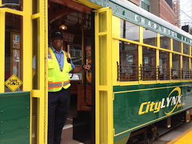
Driver Danny McQueen on Tuesday, awaiting a carload of dignitaries to launch Charlotte's streetcar. The historic replica streetcars now in use would be replaced during the expansion phase with modern streetcars. Photo: Mary Newsom
Before Tuesday morning's ribbon-cutting that launched Charlotte’s new streetcar, it seemed appropriate to check in with Ron Tober. It was Tober who originally proposed adding the streetcar to the larger transit plan for Charlotte. One might even dub him the godfather of the streetcar idea.

Tober was the Charlotte Area Transit System CEO from 1999 to 2007 – the longest-serving CATS chief to date.  The original transit plan, crafted before the 1998 voter referendum that OK’d a transit sales tax, did not include a streetcar. It roughly sketched five corridors: South (now the Lynx Blue Line), North (the still unfunded commuter rail to Mooresville), Northeast (being built as the Blue Line Extension), Southeast (envisioned running roughly down Independence Boulevard), and West possibly to the airport and possibly not.

Other than the South corridor, where the city already owned rail right of way, and the proposed extension to the northeast, it was left unclear in those early days which corridors would get bus rapid transit and which would get light rail. That did not sit well with east and west Charlotte neighborhood championswho clamored for rail service, not bus rapid transit.

In 2004, Tober proposed a streetcar to connect east and west Charlotte. It would run in rails along Beatties Ford Road, through uptown, and out Central Avenue to Eastland Mall, which at that time was open, he reminded me Tuesday morning. The streetcar idea was adopted into the 2006 transit plan update.

Some background: The newly opened 1.5-mile streetcar segment is not funded with the county’s half-cent sales tax for transit. That money goes to the Blue Line, the Blue Line Extension and to run the bus system. Not enough revenue has come in to pay to build more of the 2030 transit plan. (See New CATS chief faces funding questions.) The first streetcar leg was built with a $25 million federal grant and $17 million in funds from the city of

Wednesday, July 8, 2015

Highways - loosening our collective belts

The first vehicles drive down the final leg of I-485, June 5. Photo: Nancy Pierce
Even as the national discussion turns toward whether we are overbuilding highways, based on inflated state traffic numbers, in North Carolina those questions are rarely heard. Last month the state's largest city, Charlotte, population 800,000, where I live and work, saw the June 5 opening of the final leg of its loop highway.  It's called Interstate 485 but it doesn't touch another state, or even another county.

When the road was first discussed in the 1960s, the idea was to open more land for development, because in these parts, the growth-is-good mindset has not had much nuance to it. While the local news media saw headlines such as Last I-485 segment will be boon to locals, we at the UNC Charlotte Urban Institute, where I work and direct the PlanCharlotte.org website, decided to look deeper.

We've published some interactive maps that show just how much of the county's development has been shaped by the outerbelt highway here. A couple of images are reproduced below but find the interactive and zoomable versions at this link.


 In coming weeks we'll map population growth and traffic counts at the interchanges.

Obviously this is a fast-growing metro area, and growth was going to arrive regardless of where we put our freeways. The questions were: Where was the growth going to go? Can the highway capacity keep up with the demand created by the new development?

 The answer to the first question is now obvious. The growth flooded to the highway, leapfrogging closer in areas that even today lack for investment.  Would even more growth have leapfrogged into adjacent counties without I-485, or would the lack of the highway access have kept the development closer to the core? Who could tell?

The answer to the latter question remains unclear, although I certainly have my doubts. Even before the final link of the loop opened June 5, last December the first leg of the highway, which opened in the 1990s, was expanded from two to three lanes each direction, at a cost of $83 million.

It's still clogged.

Monday, June 1, 2015

Another lesson from Caro: the importance of robust local news coverage

One less obvious lesson of Robert Caro's The Power Broker (which I wrote about last week) is about the value of old-fashioned, shoe-leather local reporting in exposing corruption. Several of his most powerful sections recounted the neighborhood deterioration caused by the Gowanus Expressway and the blatantly destruction to families and the Bronx from the Cross-Bronx Expressway. His anger at the lack of on-the-ground news reporting from the multiple New York newspapers of the time seemed to leap off the pages at me.

Today, in my city of Charlotte, local news reporting is a fading art, because of the destruction of the revenue base for city newspapers all over the country.  Worry, if you want, about the New York Times (which back in the day appears to have ignored most of what Caro was writing about), but I worry a lot more about the hundreds of newspapers in cities like Charlotte, Raleigh, Portland, Charleston (which just won a Pulitzer), Kansas City, Fort Worth, Biloxi, Cleveland and so forth. If you live in one of those places, it's your local newspaper that has aspired to cover the community well and in-depth. (Are they perfect? Of course not. But who else is better positioned to noticing what is happening on the ground, and following a story that takes months or years to ooze along and that includes no murders or car wrecks? TV reporters? Please.)

Digital news significantly lowers the entry-cost for a news operation. No presses, no paper, no delivery. For years now, conventional wisdom among the chattering classes who observe the news media has been that hyper-local news sites have a built in audience and a built-in revenue base, if they can offer good content and their community is affluent enough.

Last week, a couple of excellent hyper-local, online news operations near Charlotte folded. Davidsonnews.net and its sister Corneliusnews.net covered their communities with serious, well-reported journalism. The community of Davidson, home to Davidson College, predates its surrounding suburban communities and possesses a historic and specific sense of itself as a "place," not just a suburb. The founder and editor, David Boraks, knew his communities and knew his business.  They are affluent places with plenty of disposable income. But online advertising was not sufficient to pay reporters -- even reporters of the species so familiar to journalism: young, inexperienced, smart and energetic. He did not pay himself much, if anything.

If a freeway were destroying a neighborhood in Davidson, Boraks and his staff would have been write there, chronicling it.

He folded. Online advertising and reader donations (he never put up a pay-wall) did not bring in enough money, even after nine years.

Traditional in-print newspapers have seen serious declines in advertising revenue, which has been their major income stream.  Online advertising has not picked up the slack. The Charlotte Observer has seen round after round of layoffs and buyouts, as have most newspapers in the nation.

If he were alive today, I'm fairly sure Robert Moses would be delighted at this turn of events. 

Friday, May 29, 2015

More lanes in Houston, and longer traffic times

Here's a great example to buttress the point I made earlier today, in "Highways, congestion and a power broker's lessons." Which was this: Since at least the 1930s planners have known that adding highway lanes does not reduce congestion, but rather counter-intuitively seems to increase it.

As reported by Thursday by Angie Schmitt in Streetsblog.net,  a Houston Tomorrow analysis of driving time on the I-10 Katy Freeway found it took 51 percent more time to get from downtown to Pin Oak on the newly expanded, 23-lane freeway than it did in 2011 right after the new lanes opened. An expansion project that ended in 2010 cost $2.8 billion-with-a-B which was $1.17 billion-with-a-B more than its original price tag.

Coincidence: The Federal Highway Administration's 2012 list of projects that details the cost of the Katy Freeway also lists the Monroe Bypass, with a due date of 2016. Better get hopping on that one, guys. Or better yet, don't.

Jay Crossley of Houston Tomorrow concludes: "Traveling out I-10 is now 33% worse - almost 18 more minutes of your time - than it was before we spent $2.8 billion to subsidize land speculation and encourage more driving."

Highways, congestion and a power broker's lessons

Frontispiece of The Power Broker maps Moses' roads, bridges, parks and playgrounds. 
The headline in this morning's newspaper could not have been more appropriate for the day I have to, at long last and reluctantly, return to the UNC Charlotte library my copy of Robert A. Caro's The Power Broker: Robert Moses and the Fall of New York.

I checked it out in September 2013. It's roughly the size of a cinder block and just as heavy, and the librarians graciously let me keep renewing it, since apparently no one else wanted the tome. Which is sad. Published in 1974, it should be required reading for anyone studying public administration, transportation, planning, urban studies, political science, sociology and journalism. I finally finished it a few months ago but after so long it felt almost like a family pet and I didn't want to part with it.

The headline today: N.C. DOT says Monroe Bypass construction has started. The article by Steve Harrison notes a lawsuit over the project is still active, and it could well be stopped for a second time.

As it happens, one of Robert Moses' faithful techniques for getting money for his projects was to start work on them

Friday, April 17, 2015

N.C. transportation funding: 'If you're not at the table, you're on the menu'

A Charlotte light rail station
If you were at the Charlotte Chamber's 2015 Transportation Infrastructure Summit this morning, you got two pointed lectures. The first, from N.C. Rep. Bill Brawley, R-Mecklenburg, was about dealing effectively with the N.C. General Assembly.

The background: North Carolina's transportation dollars aren't keeping up with needs. This is true whether you'd prefer new light rail and no roads, or new roads and no light rail, or whether you're thinking about ports, aviation and ferries. (Wonkish but important point: North Carolina doesn't have "county roads." Roads are either state- or city-maintained (or private).The state has a larger role in road-building and maintenance than in some other states.)

The gas tax, intended to support state transportation needs, is not keeping up, because people are driving less and driving more fuel-efficient cars, and transportation projects today are more expensive than in decades past.

For cities like Charlotte, growth and congestion mean more voters and businesses want mass transit as well as expanded roads. But the General Assembly today is dominated by Republicans who are more likely to represent rural or suburban districts. Here's Brawley's advice:

"Whenever you do anything to raise money for transportation ... you make people mad," he said. In that atmosphere, it's important to try to build a statewide consensus on funding before you even approach politicians. But when Charlotte comes to Raleigh seeking money for transportation projects, he said, "Charlotte comes with Charlotte-specific projects.They don't talk about the state as a whole. They don't work on building support with the state as a whole." In other words -- and this is my wording here -- act like you care about more than Charlotte.

His final words: "In Raleigh, if you're not at the table, you're on the menu."

The second lecture was even stronger. Former U.S. Transportation Secretary Ray LaHood (whose successor is former Charlotte Mayor Anthony Foxx) would have pounded the table if he'd had a table to pound. "Transportation infrastructure is at a crossroads. It's at a standstill," he said. "It's at a crisis."

"The long rich history of our country ... is about being No. 1 in transportation and infrastructure," he said. "We're not No. 1 in infrastructure any more. We're No. 16."

 "America is one big pothole!" he all but shouted. "Because we haven't invested. We haven't fixed up our roads."

As he's done for months -- years, really -- LaHood, a Republican from Peoria, Ill., pushed the idea of raising the federal gas tax 10 cents a gallon, and indexing it to the cost of living. The tax has not been raised since 1993.

"We need to bit the bullet," he said. "Voters are not going to vote you out of office if you fix a big problem"

Sunday, February 1, 2015

The Burnham backlash: Make some 'small plans'

You can barely attend any conference of architects, planners or even local town planning boards without seeing, at some spot in the PowerPoint presentation, the famous quote from Chicago architect and town planner, Daniel: “Make no little plans,” he said. “They have no magic to stir men’s blood.”

But, as Alan Ehrenhalt points out in an essay in Governing magazine, “Urban Acupuncture Is Coming to America,” that view of city building helped promote a lot of what went terribly wrong in U.S. cities in the 20th century. Urban renewal is just Exhibit No. 1. So here’s Ehrenhalt’s suggestion:

“For the next century, it might be helpful if someone came along who could offer urban practitioners a dose of Burnham in reverse. Something akin to, 'Be careful about making huge plans, because they take forever, cost too much and generate myriad unintended consequences. Make small changes that improve everyday life for ordinary people; make them right away and build on small successes to try something a little more ambitious.’ ”

Ehrenhalt recounts the work of Jaime Lerner, a Brazilian architect who became mayor of Curitiba, a city of 1.7 million, and later governor of the state of Parana. It’s pegged to the fall 2014 release of an English translation of Lerner's book, Urban Acupuncture: Celebrating Pinpricks of Change That Enrich City Life.  (Disclosure: I’m a board member of the nonprofit Center for the Living City, which found funding for the publication of the English translation.)

The overall point, of Lerner’s book and Ehrenhalt's essay, is simple but too often overlooked by urban planners, city administrators and elected officials: Sometimes a small change is better than a huge project. 

Friday, January 23, 2015

The mayor's view: Transit funding (the dilemma), a more diverse city, and more

Local dignitaries at a 2012 ceremony for the Blue Line Extension. Then-Mayor Anthony Foxx, now U.S. Transportation Secretary, is at right. (Photo: Mary Newsom)
Charlotte Magazine's Greg Lacour has posted a meaty Q-and-A interview with Charlotte Mayor Dan Clodfelter, in which the mayor discusses the city's dilemma on transit funding, what's different about being mayor vs. being in the N.C. Senate (where Clodfelter served 1998-2014) and what's different about Charlotte compared to when he was on City Council (1987-93).

The questions hit heavily on the problem the city and county face in funding any expansion of the Charlotte Area Transit System. (For more background, see this PlanCharlotte.org article about remarks Clodfelter made in  September, "Mayor: Transit sales tax funding may be at risk.")

Among his other remarks to Lacour, Clodfelter had an interesting analysis of state transit funding -- or the lack thereof. He suggested that the state would be disinclined to pay any more for mass transit projects (for the first two legs of Charlotte's light rail, the state paid 25 percent of the cost) regardless of which party is controlling state government. Why? Because statewide transportation needs are great, and gas tax revenue is lagging. Add that up and it's difficult to fund anything, he said.

On a more political note, although Clodfelter isn't saying for sure he's running for mayor, he also recently gave an interview to Qcitymetro.com. Here's that interview

(At-large Charlotte City Council member Michael Barnes this week hopped into the mayor's race, joining Democrats Jennifer Watson Roberts and fellow at-large City Council member David Howard. To date, no Republican has emerged as a likely candidate. But filing isn't until this summer, with the primary in September.)

Thursday, January 22, 2015

Why slow-growing light rail ridership should not surprise anyone

A bus in uptown Charlotte, where most bus routes begin and end. Photo: Claire Apaliski
Today's Charlotte Observer brings an article from Steve Harrison noting that ridership on Charlotte's light rail line, the LYNX Blue Line, has finally rebounded to its pre-recession levels but has not increased dramatically despite rapid growth in apartments along part of its route. See "Lynx light rail ridership back to 2008 levels."

Some background: Charlotte's first and only light rail line opened in late 2007, just in time for the massive 2008-09 recession that had Charlotte unemployment lingering in double-digits or near it for months. The northern couple of miles of the 9-mile route, closest to uptown, have seen massive apartment development in the past several years. The southern part of the route? Nada.

But the South End neighborhood – an area of old industrial buildings dating from the 1960s back to the late 1800s – is popping with hundreds of new apartments, and hopping with new microbreweries and trendy restaurants.

Car-free in Charlotte? It isn't easy by Carolyn Reid, published last June at the PlanCharlotte.org website I run, helps explain why ridership may not be growing as quickly as you'd think.

Even in South End there's little easy or walkable access to routine shopping needs like grocery and drug stores, no easily accessed, widely connected network of bike routes, nor robust bus service with headways under 10 minutes that spreads cross town. Because of lack of funding, the city's bus service – while much improved over 1990s levels – still focuses on  delivering workers to uptown rather than building a widely connected network.

South End remains a place with better transit, bike and pedestrian connections than almost any other Charlotte neighborhood. But it's still not a place where living without a car is going to be easy. Unless you're trying to go uptown, the light rail can't deliver you where you want to go.

My prediction: Ridership will zoom when the Blue Line Extension opens in 2017, taking riders to the 27,000-student UNC Charlotte campus about 10 miles northeast of uptown.